Startup Business Development

Columbia Venture Community: Project Two.Eight

In 2022, I facilitated a workshop on Deriving Insights for Customer Development through effective user experience research for the inaugural cohort of Project Two.Eight, a startup incubator for female founders at Columbia University. I also serve as a design mentor on a continuing basis. Two.Eight, or 2.8%, is the share of venture capital funding that female founders receive relative to their male counterparts. At launch, that number had declined. We are working to change this.

Technology Transfer Days: Creating Cultures of Innovation

I have served as an advisor for the Technology Transfer Days since 2014. The program has been hosted by Microsoft and the NYU Center for Urban Science and Progress and serves to connect local technology startups to members of the U.S. Army USCENTCOM and NORTHCOM Innovation Office, NASA, Department of Energy, Department of Homeland Security, National Defense University, and Navy Postgraduate School. We match companies to S&I officers for private, facilitated meetings and plan and promote a public program including presentations by U.S. Veteran Entrepreneurs and the Department of Defense’s National Security Technology Accelerator (NSTA). Several organizations who participated in the November Geodata CEO Breakfast described below have received funding through TTD.

Other partners of the Technology Transfer Days program include the Brooklyn Small Business Development Center, NYC ACRE @ Urban Future Lab, Brooklyn Law Incubator and Policy Clinic (BLIP), Brooklyn CityTech, OWASP Brooklyn and GISMO.

Impact Hub NYC, 2018-2021

I have a long relationship with Impact Hub NYC, facilitating workshops for their various cohorts, including a service design workshop for Millennial financial wellness as part of their 100 Days of Impact program in 2017 and another financial wellness workshop in 2018 when Decision Fish was part of their United Nations SDG-themed 30for30 cohort. Most recently, I facilitated a customer development workshop for Impact Hub NYC’s Blueprint 2021 Impact Fellowship focusing on customer development and user experience design.

GISMO: Geographic Information Systems Mapping Organization

I have served on the board of GISMO, a NYC based geographic information systems community, since 2013 and have been an active member since 1992 when I was a real estate researcher at Price Waterhouse. GISMO has been the NYC chapter of the New York State GIS Association since 2013 but has existed as an open user group since 1990.

I have developed programs with GISMO and New York Geospatial Catalysts (NYGeoCATS) on a series of public and private meetings to introduce companies and individuals involved in the geodata community in New York City. These meetings are being facilitated with a goal to promote open access and availability of geospatial data from providers to users. Highlights include the GISMO 25th Anniversary gala, a CEO breakfast with the former U.S. National Geo-Intelligence Agency Director Robert Cardillo and facilitated meetings with Department of Defense innovation offices. We also curated a weekend map showcase at the Queens Museum.

We are currently working on a redesigned website that reflects more of the collaborative and advocacy work at GISMO. For more information about the work I am doing with GISMO and its GIS startup events, visit http://www.gismonyc.org/events/past-events/. Visit my GISMO portfolio page to read about these significant events where I co-led, co-curated or otherwise participated in committee leadership.

NYC Charter Revisions and GIS Oversight

Since well before 9/11, GISMO, the NYC region’s oldest GIS interest group, has been working on advocacy initiatives to improve the way New York City collects, stores, shares and manages Geospatial Data and the processes and strategies around the City’s Geographic Information Systems (GIS) and related functions. Beginning in 1996, the City’s first GIS Director, GISMO member Alan Leidner, held this role until his retirement from civic service in 2004. During his tenure, Leidner oversaw NYC’s emergency mapping program in one of the country’s most complicated rescue and recovery operations, the September 11, 2001 attack on the World Trade Center.

Just two years prior to 9/11, the City had launched a common base map for all agencies to use in GIS applications. Prior to the 1999 base map, there was little coordination between agencies on the underlying coordinates of various features on maps. As a result, data such as street center lines (which were available from the US Census though not always accurate) and building footprints would not match up with the level of accuracy needed for an effective response in an emergency situation. As City agencies created their own maps and datasets, using proprietary systems and software whose license agreements precluded data sharing, it was becoming increasingly difficult to form a common operating picture. This created difficulties for routine maintenance projects like coordinating access, excavation and repair of street corners and threatened larger operations.  After the World Trade Center attacks, when visible landmarks were no longer available, the new base map saved time, money and lives.

But things have changed since 2004. When Leidner retired, a new GIS Director was appointed, but he was not given the same level of responsibility and did not get the assistant commissioner title the post had carried previously. Laws providing the public open access to a multitude of agency datasets created a market for public information and tools created taking advantage of them. Mayor Bloomberg wrote an executive order that created the Mayor’s Office of Data Analytics, but the mandate did not cover the kind of sensitive data that would be required to handle multi-department programs and, crucially, emergencies. As a result response to events like Hurricane Sandy was fractured, affecting the ability of emergency services, DEP, MTA, ConEd and other entities to coordinate their activities.

GISMO recently published Guiding Principles and Policies for New York City’s Geospatial Architecture outlining its position on the role of geospatial technology and governance in NYC government. It presented the Principals and Policies work at a public forum at Hunter College in April 2018. GISMO further pursued its position that NYC must have a GIS Director and coordinating committee made up of GIS leads at all city agencies and is recommending a Charter amendment or legislation to make this happen.

GISMO posted its introductory statement, video and written testimonies regarding the proposed amendments to the New York City Charter at http://www.gismonyc.org/events/amend_nyc_charter/.  These testimonies were delivered to the New York City Council Charter Committee on April 30, May 2, May 7 and May 9, where several GISMO members, including myself, testified at the public hearings.

Through this Charter initiative we have advanced the cause of GIS in NYC by bringing our demands for better governance into the public forum. GIS saves lives, protects infrastructure, supports planning, improves City services, increases tax collections, and enhances economic development. We estimate that GIS at least doubles the analytic powers of traditional IT. We call on City government to recognize these facts and act accordingly.

You can find my testimony (gismonyc.org) and video (YouTube), starting at 02:25:15 but to get the full context, it’s best to review the statements in order. To explore how lives are saved by faster 911 response visit NYS GIS Association’s GISCalc tool created by Decision Fish, Results that Matter Team, and funded by the Fund for the City of New York.

If you are interested in learning more about GIS governance in New York City, contact GISMO at info@gismonyc.org or contact your New York City Council representative.

Press Mentions: Beta Phi Mu Initiation Speech

New Initiates and Guest Speaker Noreen Y. Whysel

Noreen Whysel addressing the 2017 Initiation Class of Beta Phi Mu Theta at Pratt Institute School of Information

“A lovely Initiation Ceremony and Dessert Reception were hosted by the Beta Phi Mu Theta Chapter on May 17, 2017.

“Guest Speaker Noreen Y. Whysel (SILS ’14) gave a fantastic keynote speech, which she described below:

Dreams, Resilience and Making a Difference
Our goal as we embark on our journey as Pratt SILS graduates is to make a difference. Whether we leave Pratt to become a school librarian, a legal librarian, a UX designer, or an archivist, we stand as a gateway between a deluge of Information and the people we serve.

“Using an example of a proposed 9/11 geographic archive, Noreen Whysel explained how between our dreams and our goal of making a difference is resilience.”

The full talk transcript and presentation slides

Exploring a 9/11 Geographic Archive

Oral history as a primary source is being revived through initiatives like Story Corps and World Pulse and through improved storage capacity to archive and exhibit personal stories, making it less expensive for even the smallest and least funded groups. We are moving toward an environment where alternative narratives can be both manipulative (alternative facts, post truth) and expositive, as more and more under-represented groups get access to telling their story. So the ways that we share and interpret of stories in the future will be pretty interesting.

The story of the creation of the maps for first responders and emergency managers is sweeping and personal. I am currently exploring the creation of a 9/11 geographic archive. The archive will serve as a repository of artifacts and a history of participation by geographers, programers and spatial data technologists during the response to the World Trade center attack on September 11, 2001. Funding for the project was provided by the Fund for the City of New York as part of a grant to develop a Center for Geospatial Innovation.

More information and thoughts to come!

Map Mosaic: From Queens to the World

Amy Jeu and I curated a weekend exhibit, Map Mosaic: From Queens to the World, on October 29-30, 2016 at the Queens Museum celebrating the map-making community. The event featured talks and demonstrations as well as a hall dedicated to paper and digital maps submitted from the private collections of members of the GISMO community. These maps represent a wide range of themes including the diverse Queens neighborhood and demographics, urban planning, environmental studies, election analysis and more.

Visitors at Map Mosaic: From Queens to the World, Queens Museum, NY
Mezzanine Level with map exhibit and children's activity tables at Map Mosaic: From Queens to the World, Queens Museum, NY
Five maps with placards at Map Mosaic: From Queens to the World, Queens Museum, NY
Table with flyers and Dr. Suess book for children's story hour at Map Mosaic: From Queens to the World, Queens Museum, NY
Four visitors at interactive map station, one wearing 3D glasses at Map Mosaic: From Queens to the World, Queens Museum, NY
Interactive map station with 3D glasses at Map Mosaic: From Queens to the World, Queens Museum, NY

My Submissions

For my contribution to the exhibit, I created a cutout map of the 1964 World’s Fairgrounds to teach children how map layers work in GIS. This series of maps, printed on acrylic transparency sheeting can be stacked to show through various layers: Base Map, Parks, Buildings, Streets/Paths. We also provided additional paper and colored pencils for children to use. This activity helped younger visitors to understand the concept of map layers in GIS.

Because the event was held over Halloween weekend, I also contributed a set of themed maps with Halloween parade routes and a “Crime of the Century” story map retelling the activities from the 1934 Ice House Heist in Brooklyn and Upper West Side Manhattan. The piece included reproductions of aerial photographs from the time period.

Documentation

Each item in the exhibition included a placard indicating the name of the mapmaker, the materials used and a brief description of the subject. We used icons to indicate whether an interactive version was available at the computer stations or that the mapmaker is also a speaker in our forum.  

interactive

Interactive Map

speaker

Speaker

Amy Jeu created the flyer and copy for the exhibit which was published on the Queens Museum website and the signage used for the exhibit and presentations. I created the placards and the online exhibit catalog.

Archive

The Map Mosaic event was privately curated. Queens Museum published an announcement and the exhibit catalog and list of interactive maps are available at GISMO’s Website. The acrylic manipulative work is located in the GISMO archive. All maps produced by the NYC Office of Emergency Management were donated to the Queens Museum and all other, individual artwork was returned to the artists.

Queens Museum Website Announcement
Exhibit Catalog
Interactive Maps

State of the Map Bonus: Satellite Selfie

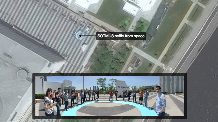
SOTM Satellite Selfie, CartoDB

June 6-8 was OpenStreetMap’s State of the Map Conference at the United Nations. I volunteered at registration and during morning sessions and was able to attend interesting talks on OSM data in Wikipedia, the Red Cross presentation on OSM in disaster response and developing a GIS curriculum in higher education.

One of the highlights was a satellite selfie. Led by a team from DigitalGlobe, a group of about 20 attendees created a large UN-blue circle on the ground and waited for the WorldView 3 and GOI1 satellites to flyover for a routine scan. Orbiting at 15,000 miles per hour about 400 kilometers above Manhattan, the WorldView 3 was expected to take images that would include UN Plaza. The resulting satellite image collected at 11:44am is available on the CartoDB blog (image above), courtesy of CartoDB CEO, Javier de la Torre. Huge thanks to Josh Winer of DigitalGlobe who took time to explain the physics of satellite imagery and kept us entertained while we waited for our not-so-closeup.

Upcoming Events: Agency GIS Forum and Brooklyn Technology Transfer

Two upcoming events brought to you by GISMO and OWASP Brooklyn.


Agency GIS Forum

GISMO

Thursday, February 5, 2015
100 Church Street
2:30 – 4:30 PM

atelier-digital-world-map

Join us to hear a round of lightning talks given by GIS directors and managers of City agencies. This will be a great opportunity to learn about innovative GIS projects and programs being implemented across municipal government, and to meet with colleagues from other agencies.

GISMO and the Municipal Information Technology Council (MITC) are co-hosting this event. MITC is the organization of City IT professionals. This get together is a unique opportunity to learn about how NYC’s nation leading GIS program is progressing and to have direct contact with the City GIS leadership and staff.

Registration Required

Attendance at this meeting will be by RSVP only and is reserved exclusively for GISMO members*, MITC members and City agency GIS personnel. Please register early as there are a limited number of seats available, and this event will fill up fast!

* GISMO membership means paid dues for the 2014 – 2015 membership year. People on the GISMO mailing list who do not satisfy the above criteria will have to join GISMO and pay their dues in order to attend.

Register at http://www.gismonyc.org/events/next-event/


Technology Transfer – Creating Cultures of Innovation

OWASP Brooklyn

Saturday, February 28, 2015
2:00 PM to 6:00 PM

NYU Poly Pfizer Auditorium
5 MetroTech Center, Brooklyn, NY

To attend this event, you must also register on Eventbrite at this URL to get your ticket: https://www.eventbrite.com/e/technology-transfer-creating-cultures-of-innovation-tickets-15406554419

Description: TBD

Facilitator – Moderator: TBD

Speakers:

Zach Tudor, SRI, Author of Technology Transfer: Crossing the “Valley of Death” – his research on Cybersecurity startups will discuss “Creating Cultures of Innovation” Bio: http://www.csl.sri.com/people/tudor/

Professor Nasir Memon, NYU Polytechnic will discuss NYU Poly’s Technology Transfer. Bio: http://isis.poly.edu/memon/

Brett Scharringhausen, USCENTCOM CCJ8-Science & Technology Chief, Discovery & Integration will discuss CENTCOM Requirements.

Ryan Letts, Veterans Advisor, Brooklyn SBDC CityTech will present and discuss SBA research on Veterans Startups in NY.

Semiotics in Mapping and Emergency Response

On November 1, 2014 I participated in a Semiotics Web and Information Architecture meetup at New York Public Library. Mypresentation, “Semiotics in Mapping and Emergency Response,” discusses symbology in mapping as an aspect of semiotics and presents an example of emergency response map symbology and a discussion of applications for first responders and broader uses.

Joining me were Loren Davie on Conversational Architecture – http://telltrail.me/ and CAVE language, Laureano Batista who discussed Steps Toward a Pragmatic Philosophy in the Age of Big Data and Neural Networks and Donald Gooden, the NY Chapter Leader of the OWASP Foundation, who spoke about the OWASP.org.

Read a detailed write up of this event by Nathaniel Levisrael at http://scignscape.appspot.com/meeting1-summary

Emergency Management — NYC OEM Timeline


Client: NYC Office of Emergency Management
Date: May 27, 2014
Visit Website

In 2011, I participated in the NYC GeoSymposium 2001-2011-2021, which took a look at the advances and challenges of Geographic Information Systems in emergency response since 2001. I had been working with colleagues at GISMO for many years to draw attention to the important role geographers played in the 9/11 rescue and recovery. The GeoSymposium was a great experience, because it intended not just to honor those who participated in these efforts, but also to highlight the need to preserve the thousands of maps that tell the story.

My own contribution to the GeoSymposium was to explore the legacy of these efforts by examining the technological improvements at the Office of Emergency Management in the context of emergency events that had occurred since 2001. I was looking for a way to present time-based information in a map format and also to start a conversation with attendees about the history of emergency response technology and the importance of the preservation of geographic artifacts. My project contained a map of New York City with events plotted and color-coded by discrete periods, characterized by a common group of new technologies. An online version of the map is available at ArgGIS Explorer Online.

OEM-Incidents-interactive-map

View Interactive Map


Download OEM Incident Map – Poster

OEM-Incidents-screenshot
Screen Shot 2015-09-10 at 2.45.54 PM

The map highlights how the events surrounding 9/11 prompted improvements in incident management technology. Attendees, including the keynote presenter and eminent information designer, Edward Tufte, gathered around to discuss their experience with the events I had mapped and to offer advice on ways to enrich its design. (Some of Mr. Tufte’s comments led to further improvements which you can see via the links above.)

Simply talking about how to improve the map was an exercise in exploring history and memory: how people understand what happened, how events are related to one another, how what you choose to include and what not to include can influence a person’s understanding of the events, how the description of one event can bring to mind another similar one, etc. It was thrilling to observe the spontaneous conversation that started all because of a three by four foot piece of foamboard.

For more details and context around the planning for a 9/11 Map Archive, see my blog post, Towards a 9/11 GeoArchive.

Portfolio: GIS and Mapping

I have over 20 years of experience in GIS and Mapping, including both modern and historical mapping projects for urban planning and infrastructure, emergency response, and digital archiving of 9/11 geographic materials. I have been a board member of GISMO since 2013.

Featured Interactive Maps

Geodata Startup Business Development:  I am working with GISMO and the New York Geospatial Catalysts (NYGeoCATS) on developing an ongoing series of public and private interactions to introduce companies and individuals involved in the geodata community in New York City. These meetings are being facilitated with a goal to promote open access and availability of geospatial data from providers to users.

Screenshot from the 9/11 Geospatial Archive on GitHub

9/11 Geospatial Archive: Along with members of GISMO, a NYC GIS community, and funding from the Fund for the City of New York, I curated a digital archive of geospatial artifacts related to the September 11, 2001 World Trade Center bombing.

GitHub Repository

Map Mosaic: From Queens to the World: I co-curated a Queens-themed festival and exhibit at the Queens Museum with Amy Jeu of Hunter College. The exhibit included a series of live presentations and children’s activities as part of the 25th Anniversary of GISMO.

Museum Website
Exhibit Catalog
Interactive Maps

Emergency Management: OEM Timeline: An interactive map presentation developed in ArcGIS for the NYC Office of Emergency Management and presented at various conferences and events.

View Interactive Map
Documentation

More GIS and Mapping Projects